


Introduction: What Is an Alaska Tsunami?
An Alaska tsunami is a powerful ocean wave triggered by seismic or geological activity in or near the waters surrounding Alaska.
These waves can strike with little warning, causing devastating damage to coastal communities.
Alaska’s unique geography, marked by rugged coastlines, deep fjords, and active fault lines, makes it one of the most tsunami-prone regions in the United States.


From the towering wave of Lituya Bay in 1958 to the recent 7.3-magnitude earthquake in July 2025, Alaska tsunamis have left indelible marks on both the landscape and the collective memory of its people.
This article explores the science, history, and future of Alaska tsunamis, offering insights into how residents and authorities prepare for nature’s most unpredictable threat.
Geography and Seismic Setting
Alaska sits atop the Pacific Ring of Fire, a horseshoe-shaped zone known for frequent earthquakes and volcanic eruptions.
The Alaska-Aleutian subduction zone, where the Pacific Plate slides beneath the North American Plate, is one of the most seismically active regions on Earth.
Key geological features contributing to tsunami risk include:
Subduction zones: Capable of generating megathrust earthquakes
Strike-slip faults: Like the Fairweather Fault, which triggered the 1958 Lituya Bay tsunami
Volcanoes and glacial fjords: Prone to landslides and eruptions that displace water
This volatile setting means Alaska experiences over 20,000 earthquakes annually, with many occurring offshore or near coastal areas, prime conditions for tsunami formation.
Causes of Alaska Tsunamis
Tsunamis in Alaska are typically caused by:
1. Underwater Earthquakes
Most Alaska tsunamis originate from subduction zone earthquakes, which cause vertical displacement of the ocean floor. When the seabed shifts, it pushes water upward, creating waves that radiate outward.
2. Landslides
Both submarine and subaerial landslides can trigger tsunamis. A notable example is the 1958 Lituya Bay megatsunami, caused by a massive rockfall into a fjord.
3. Volcanic Activity
Explosive eruptions or collapses of volcanic flanks, like the 1883 Augustine Volcano event, can displace water and generate tsunamis.
4. Glacial Retreat
As glaciers melt and retreat, they destabilize surrounding terrain, increasing the risk of landslides and tsunamis. The 2024 Pedersen Lagoon tsunami, caused by a landslide triggered by heavy rain, is a recent example.
Historical Alaska Tsunamis
Alaska’s tsunami history is rich and sobering. Here are some of the most significant events:
1964 Great Alaska Earthquake and Tsunami
Magnitude: 9.2 (second-largest ever recorded globally)
Impact: Triggered local and distant tsunamis
Casualties: Over 130 deaths, mostly from tsunami waves
Reach: Waves hit Alaska, the U.S. West Coast, and Hawaii
1958 Lituya Bay Megatsunami
Cause: Landslide triggered by a 7.8-magnitude earthquake
Wave height: 1,720 feet, the tallest tsunami ever recorded
Impact: Swept away trees, boats, and cabins; 5 deaths
Legacy: Redefined scientific understanding of megatsunamis
1883 Augustine Volcano Tsunami
Cause: Volcanic flank collapse
Impact: Waves reached 20 feet; flooded villages and killed several Aleut hunters
2015 Icy Bay Tsunami
Cause: Landslide into Taan Fjord
Wave height: 600 feet
Impact: No casualties, but significant environmental damage
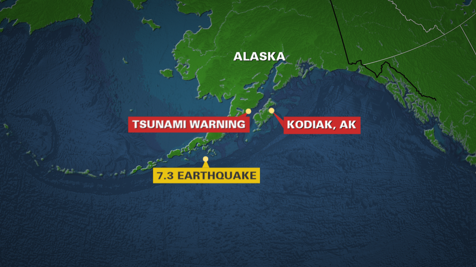
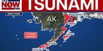
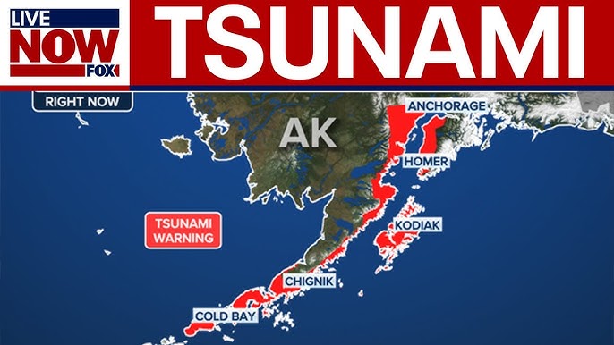
Recent Event: July 2025 Alaska Tsunami Warning
On July 16, 2025, a 7.3-magnitude earthquake struck near Sand Point, Alaska, prompting a tsunami warning for a 700-mile stretch of coastline.
Key Details:
Epicenter: 54 miles south of Sand Point
Depth: 20.1 km (shallow, increasing surface impact)
Warning zone: Kennedy Entrance to Unimak Pass
Response: Evacuations in Cold Bay, Kodiak, and King Cove
Although the tsunami was minor, recorded at just 0.2 feet near Sand Point, the event reignited concerns about Alaska’s preparedness and the reliability of warning systems.
Science Behind Tsunami Formation
Tsunamis are not just “big waves.” They are series of waves caused by the displacement of water. In Alaska, the most common triggers are:
Thrust earthquakes: Vertical movement of the seabed
Landslides: Sudden mass movement into water
Volcanic eruptions: Explosive displacement of water
The first wave is not always the largest, and tsunamis can last for hours.
In fjords like Lituya Bay, narrow geometry amplifies wave height, creating megatsunamis that defy conventional models.
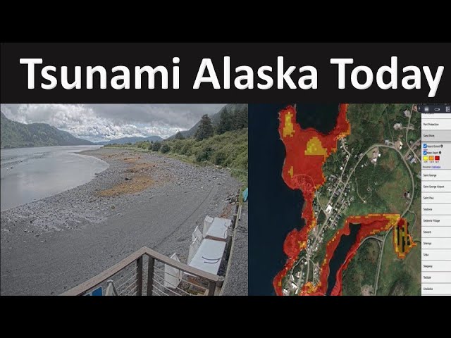
Warning Systems and Preparedness
Alaska’s tsunami warning infrastructure includes:
National Tsunami Warning Center (NTWC)
Located in Palmer, Alaska
Monitors seismic and oceanic data
Issues warnings, advisories, and watches
NOAA and USGS Tools
DART buoys: Detect sea-level changes
Tide gauges: Measure wave height
Seismic sensors: Track earthquake magnitude and depth
Evacuation Protocols
Move 50 feet above sea level and 1 mile inland
Follow sirens and alerts
Avoid beaches and harbors until “all clear” is given
Despite improvements, challenges remain:
Alert fatigue: Frequent warnings with minimal impact
Remote communities: Limited access to evacuation routes
False alarms: Balancing urgency with accuracy
Environmental and Cultural Impact
Tsunamis reshape landscapes and affect ecosystems:
Deforestation: Waves uproot trees and vegetation
Sediment displacement: Alters marine habitats
Cultural loss: Destroys historical sites and Indigenous lands
In Lituya Bay, the 1958 wave left a visible trimline, a scar in the forest still detectable by satellite today.
Future Risks and Scientific Research
Alaska’s tsunami risk is expected to grow due to:
Climate change: Accelerated glacial retreat increases landslide potential
Population growth: More people living near coastlines
Infrastructure vulnerability: Ports, oil pipelines, and fishing hubs at risk
Ongoing research includes:
AI-based warning systems
Real-time seismic modeling
Community education programs
The Alaska Earthquake Center and USGS continue to study fault lines, landslide zones, and tsunami propagation to improve forecasting and resilience.
Conclusion: Living with the Alaska Tsunami Threat
The Alaska tsunami is not just a natural hazard, it’s a reality woven into the state’s geography, history, and identity.
From towering megatsunamis to minor advisory-level waves, Alaska’s coastal communities must remain vigilant, prepared, and informed.
As technology improves and scientific understanding deepens, the goal is not to eliminate the threat, but to mitigate its impact.
Through education, infrastructure, and respect for nature’s power, Alaska can continue to thrive in the shadow of the waves.
Frequently Asked Questions
Q. Why is Alaska especially prone to tsunamis?
Alaska sits on the Pacific Ring of Fire, where the Pacific Plate subducts beneath the North American Plate. This tectonic activity causes frequent earthquakes, landslides, and volcanic eruptions, all of which can trigger tsunamis.
Q. How fast can a tsunami strike after an earthquake in Alaska?
In Alaska, local tsunamis can arrive within minutes of an earthquake or landslide. These “near-field” events offer little time for evacuation, making rapid response and awareness critical.
Q. What was the largest tsunami ever recorded in Alaska?
The 1958 Lituya Bay megatsunami holds the record, with a wave reaching 1,720 feet in height. It was caused by a massive landslide triggered by a magnitude 7.8 earthquake along the Fairweather Fault.
Q. What should I do if I feel a strong earthquake near the coast?
If shaking lasts 20 seconds or more, immediately evacuate to higher ground, even before an official tsunami warning is issued. Tsunamis can follow quickly, especially in fjords and bays.
Q. What’s the difference between a tsunami warning and a tsunami advisory?
A tsunami warning means a dangerous wave is imminent, evacuate immediately. A tsunami advisory indicates strong currents or waves may occur, stay away from the shore, but widespread flooding is not expected.
Q. Are there specific areas in Alaska at higher tsunami risk?
Yes. Coastal regions like Kodiak, Cold Bay, Homer, and Prince William Sound are considered high-risk zones due to proximity to fault lines and landslide-prone terrain.
Q. How can I stay informed during a tsunami threat in Alaska?
Tune into the National Tsunami Warning Center, NOAA weather radio, or local emergency broadcasts. Sirens, text alerts, and community evacuation maps are also vital tools for staying safe.